


Sun 15th Jul, 2012
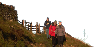
Howgills Walk
Members: Bob Kelly, Dave Wylie, Brian Taylor, Keith Williams, Phil Ramsbottom.
A small select party gathered on a grey but dry day at the foot of Carlingill –by recent standards quite a good day if a little cool for the time of year.
After a slippery river crossing during which I managed to get my clean pants covered in very wet mud (100 metres walked), the first part of the walk went very well as we followed a series of good paths climbing steadily up on to Archer Moss. The angle must have been easy as we were all able to chat away quite freely without any noticeable gasping for air. We stopped on top of Rispa Pike to take advantage of the only shelter of the day to get out of the wind and enjoy the views and our elevenses.
From here we followed the broad ridge down into the Langdale Valley, only to find two rivers blocking our way, the second was crossed by an old packhorse bridge but to reach that we first we had to cross the first. All five of us managed it without mishap, although I suspect we chose five different crossing points.
Another nicely angled track led us up on to Langdale Knott by which time Keith decided that it was lunchtime. Once refuelled we started the really good walking along the grassy ridge towards the Calf, in the distance there were some distinctly ominous looking blue/black clouds building around the summit and sure enough a quite heavy shower hit us with half a mile to go. Up to that point I was almost managing to keep up with what turned out to be a brisk pace, but after I was forced to stop to cover up I had to be content to lead from the back as the party became more and more stretched out. To be fair they did allow me to catch up at the Calf before racing off again, only to wait for instructions at each branch of the complicated ridge system.
The rain soon stopped, to be followed by patches of mist which threatened to block the views, but it never really built up enough to cause any navigation problems. By the time we were on the long descent from Knowles the sun had appeared and it was quite warm with extensive views out to the Lakes and the sea.
In the end it was almost a shame to push our way through the wild ponies, get back to the cars and drive home on a very pleasant sunny afternoon.
Sandy and Jim Gregson met up at the start of the walk but chose to do their own thing and were not spotted all day after that, they did leave a note to say that they had enjoyed a good walk.
Phil Ramsbottom
Meet Promo:
Please join me for a walk in this wild area.
For the unfortunate people who have not had the pleasure this is as wild an area as you will find South of Scotland, steep sided valleys separate grassy ridges with very few distinct features, what an area to test your map reading. If you are on your own you will find the sheep excellent listeners – they have never argued with me anyway.
Meet at 09:45 for a 10:00 start at the kink in the minor road heading South to Sedburgh ie just after where the road crosses Carlinggill Beck (ref SD 624 996).
The best approach seems to be the M6 to junction 38. Into Tebay, then take the A685 heading South to Kendal, this crosses over the M6, then just over 1 mile later the minor road turns of left to go under the M6. Watch for the left turn just before you drive into a farmyard. Meet about 1 mile along this road. There is parking for about six cars.
The route will involve climbing out of Carling Gill towards Blease Fell, then crossing over to the flat ground between Uldale Head and Rispa Pike, down Uldale End to cross Langdale Beck (possible difficult river crossing if raining!!!). Up Langdale Beck for a couple of miles before the lung-busting climb straight up the side to gain the ridge just North of West Fell. From here we can follow the ridge over West Fell, Hazelgill Knott and on to The Calf. The route finding then becomes tricky as we work our way back over White Fell Head, Busk Howe, Breaks Head, Fell Head and Linghaw. This is just 12 miles, but almost 1150 metres of ascent, so it is not for the fainthearted – and there is no easy escape route (unless you come with a very friendly driver).
Best Map – Harveys Superwalker Howgill Fells, but if you haven’t got this I will bring along a couple of spare maps with the route marked on them.
Phil Ramsbottom


