


Fri 21st Jul - Sun 6th Aug, 2017
Vallorcine - French Alps
This meet is now confirmed with people booking flights and ferries. Please contact Andy directly if you would like to know more. If you know enough about the area already and are sold on it, please just click the ''intend to attend'' button when logged in.
As you would expect, there is something for everyone: low level valley single pitch and multi-pitch rock climbing 15 minutes walk from the campsite, multi-pitch Alpine rock routes on the Aiguille Rouge, easy Alpine routes accessible from this end of the valley, hut to hut or single day walks, lots of uplift to save your knees, and of course the magnificence of the Mont Blanc range.
Getting there:
By car
There is the option to drive out on a lift share – please contact me asap if you are thinking about driving or if you need a lift so we can start to figure out the logistics.
Calais to Geneva is about 9 hours via Toll roads.
Flights:
For those with less holiday time, there is the option of flying to Geneva and getting a train or bus or sharing a minibus together to Chamonix / Vallorcine.
Easyjet EZY1949 Outbound Fri 21st July Manchester 10.50 – Geneva 13.40 (1 hr 50 min) – the drive is less than 2 hours to Vallorcine so we could be set up on the campsite by late afternoon.
Easyjet EZY 1954 return Sunday 30th July Geneva 21.55 – Manchester 22.50 (1 hr 55min). The late flight gives us an option to still do something on Sunday or be returning from a trip in the mountains.
Flights are currently about £260 including a 20kg hold bag both ways.
The Campsite
We have chosen Vallorcine (1260m) as it is a little quieter. http://www.chamonix.com/camping-des-montets,117-212994,en.html
All the usual facilities you would expect at a French campsite and reasonably priced.
Price electricity/day: 2.20 to 3.20 €
Price adult / day: 4.20 to 4.80 €
Price child / day: 2.90 to 3.50 €
Price car caravan / day: 5.30 to 6 €
Price tent/day: 2.50 to 4.50 €
Price car/day: 1.30 to 1.70 €.
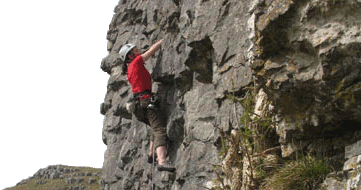
Valley Cragging
The nearest crag at Vallorcine is just 15 mins walk from the campsite with routes from 4a to 6b. Mostly single pitch but there are a smattering of four and five pitch routes at reasonable grades. Routes are bolted but a minimal rack of trad gear advised for the harder routes. 45 mins walk north of Vallorcine village on the Swiss border is Barberine crag, larger and more extensive with a bigger grade spread of routes (5b to 7c) at the slightly harder end of things, both slabby and steep. Just the other side of the Col de Montets (1461m), an hour and a bit easy walk from Vallorcine or the free bus / car (10 mins max) are the extensive crags of Les Cheserys offering high quality multi-pitch bolted climbing on south facing slabs and walls at mid grades (5a to 6b) with no lifts required.
Alpine Climbing direct from Vallorcine (or Le Tour)
Vallorcine has easy access to some great easier classic Alpine climbs, at a good altitude for acclimatisation before moving on to some of the higher peaks and routes. Uplift is direct from Vallorcine (to 1950m) or Le Tour (to 2250m) and the main two huts for climbers in the area are Refuge Albert Premier (2702m) and Cabane du Trient (3102m). Examples of peaks and routes include Traverse (PD) of the main ridge of Aiguille du Tour (3544m); South Ridge (D), Aiguille Purtscheller (3478m); Northwest Ridge (PD-), Tete Blanche (3421m); Northwest Ridge (F+), Petite Fourche (3520m) and the Forbes Arete (AD) Aiguille du Chardonnet.
Alpine Climbing in the rest of the Mont Blanc Range
There is so much choice of all styles (rock, mixed, mountaineering, easy alpinism and north face classics) and at all grades that even making an attempt at listing a few would be futile. Buy a guidebook!
The Aiguille Rouge
This is the area on the western side of Chamonix valley. There are no glaciers and routes are easy up and down to the valley in a day, although there are good bivi sites and two huts Refuge du Lac Blanc (2350m) and Refuge du Bellachat (2152m). All routes here are rock routes, most are climbed in rock shoes, most have a minimum of bolted belays, and many have bolts on other sections. As with all Chamonix rock climbing a good rack of middle sized cams is very helpful.
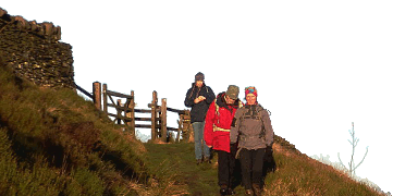
Walking
There is lots of walking in the area; lower in the valley, linking huts or using the uplift. Many guidebooks are available.
Guidebooks and Maps
The best new guidebook is probably the Rockfax Guide http://www.rockfax.com/climbing-guides/books/chamonix/
Another one often recommended for easy alpinism and alpine walking: Mont Blanc - easy ascents and glacier hikes
For high level rock routes only Mont Blanc and The Aiguilles Rouges - Rock Routes
The Alpine Club guidebooks give more detailed (but dated) coverage.
There are many more books as well.
A good guide for walkers is reputed to be Mont Blanc - A walkers Guide also the Ciccerone guide Mont Blanc Walks
The French 1:25,000 are a good bet, and the excellent Swiss maps cover quite a bit of the area as well.
HD Panoramics with Peak names and ultra high res zoom.
If you havn't come across this before then you are in for a treat. Watch it on the largest computer screen you have available - it's not so impressive on a mobile. Fast Broadband essential.
Further details will be published in as time progresses.
Andy S


