


Sun 11th Aug, 2019
Yorkshire Watershed Walk
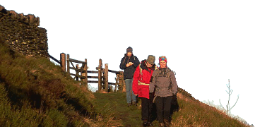
Members: Dave Wiley, Iain McCallum, Phil Ramsbottom, Keith Williams (meet leader).
Mid-August, so most sensible people were either in the Dolomites, Kirgizstan or on a sunny beach, none of which Gorple reservoir can compete with. Add to that a weather forecast featuring mainly low cloud and drizzle punctuated with heavier bursts of rain – you get the picture. So the biggest surprise was that anyone turned up at all and there was I thinking that I could just slink off home and read the Sunday papers. No such luck.
There was nothing for it but to don the waterproofs and head for the hills, or initially, hillocks. A huge area of Milnrow Sandstone to the south of Hurstwood reservoir has been quarried from the 18th century using both conventional methods and “hushing”. Hushing involved using a powerful stream of water to excavate for limestone blocks carried by ice from the Yorkshire Dales. However, these waste mounds are mainly the tailings from decades of conventional quarrying.
Once we got going we soon reached the watershed and descended towards the Gorple reservoirs, stopping briefly to consider the justification for creating Gorple farm at over 400m at a time – certainly pre-1850 - when the climate was even more severe than now. Building this substantial farmhouse alone was a serious undertaking. In addition, there are hundreds of metres of drystone walls enclosing what is now a boggy mess. There is no obvious date stone but elsewhere in the south Pennines 1680 – 1750 was a period of great activity due to an expanding population and demand for wool.
The Pack Horse Inn at 1610 pre-dates even the farm. It is located on important pack horse routes from Burnley and Colne to Hebden Bridge and Halifax. These were used to carry lime from the hushings at Hurstwood and salt from places like Saltersford. Today, we were more interested in beer and butties before starting the return leg across Heptonstall Moor. Iain and I had walked this a number of times and I thought that I knew which line we had taken.
That proved to be wrong and having left the Pennine Bridleway too soon, the green line on the map quickly turned out to be a morass of turk’s heads. Iain and Phil quickly picked a better route while Dave and I ploughed on to another huge ruined farmhouse at Raistrick Greave before meeting up again on the main track between the reservoirs. At least the cloud base had lifted by then and the sun was even fitfully making an occasional appearance.
From there we simply retraced our steps along the bridleway back to the carpark at Hurstwood. Although not a promising start, we had an enjoyable day out notable for a lack of cobwebs, not to mention the excitement of the Dolomites or Kirgizstan.
Keith Williams
Meet Promo:
The Yorksire Watershed Walk is a circular walk from Hurstwood near Worsthorn, Burnley (SD8818 3129) to the packhorse Inn, Gorple (SD9515, 3165), and back again.
The route follows the south-east side of Hurstwood Reservoir by the most extensive area of hushings in North West England. It then picks up the Pennine Bridleway towards Widdop Reservoir before turning south to Reaps Water, Gorple Lower Reservoir and the Pub.
The return route takes a more southerly line to Raistrick Greave (SD9323 3085), north back to Reaps Water, north-west across Black Moor to Gorple and Spring Head (SD9144 3200). The final leg is down Cant Clough Reservoir and the farm track above Cant Clough back to the carpark.
Distance: 11.5 miles
Ascent: 1700 feet
Mud: Plenty, but some good tracks as well
Parking: Plenty of free spaces (and some paid-for as well)
Meet: 9:45am
Pub: Open for though who want it
Keith Williams


