


Sun 11th Apr, 2021
Training: Navigation for Hikers and Hillwalkers
Attendees: Emily Thompson, Nils Elgar, Gowrie Sisupalan, Duncan Zerafa, Andrew Pierce, James Meakin, Joe Dugdale
The meet started at Marsden train station with a chance for everyone to meet 5 month old Névé so he could show off his recent training. After a round of hellos he then proved to Emily and Jared that he can do ‘downstay’ with lots of distraction around him. Obviously for a treat or two! Jared and Névé left for a walk and we headed into the village.
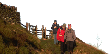
From here we headed up the Wessenden Valley onto Marsden Moor, initially using 1:50,000 maps – thanks to Marsden Moor being conveniently across the corner of two 1:25,000 maps and Emily having only suggested bringing the Dark Peak map.
After calculating individual 100m pace counts and with lots of discussion about contours, compass use and other terrain features we embarked on a stomp across the moors. Counting and staring at compasses on a mission to find a grouse butt. Not any old grouse butt, but number 5 on the map. Or number 6 as it turned out to be when we got there. Though you there was a bit of a discussion about whether it was really a grouse butt or not.
Having decided they were pretty difficult to find, even when stood next to them as they’re no longer in use, we continued on. We ventured further into the moors looking for specific contour features, as we headed towards Black Moss Reservoir.
Everyone was spot on with navigation and hopefully learnt something or got chance to have a practice of skills they’ve not used for a while. We managed to escape any passing snow shower and were lucky to have glorious sunshine all day – perhaps not that ideal for a navigation course!
Emily Thompson
Meet Promo:
The course will be delivered by club member Emily Thompson who is a qualified Mountain Leader and registered provider of the National Navigation Award Scheme.
The 1 day course teaches navigation skills for use on open moorlands and in the mountains away from footpaths.
The course will be tailored to the abilities of the group so all welcome. Booking is essential as there are limited places.
During the day you will develop skills required to navigate to detailed features. We will look at accurate compass work, and an ability to use a multitude of navigational techniques to travel across country. You will learn which techniques are appropriate for specific terrain, for example; choosing an appropriate attack point, using pacing and timing, contour interpretation, navigational tactics and route finding. The skills learned are essential for navigating in poor visibility and for night navigation.
The course is free to members, and I hope you will all consider joining for a day of skill building before summer.
Emily Thompson
")
")


