


Sun 28th Nov, 2004
Mid Wales Walk
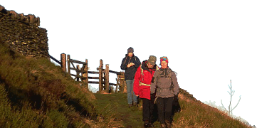
Finally, this year's 'WWW' actually made it over the hills, though a little later starting than intended due to the inherent time consuming complexity of collecting 8 into 2 cars (and having certain members still in bed at departure time). Just as the early inviting blue skies sneaked off, the 8 set off up the track to Arenig Fawr, with several other parties out on this side. The crags didn't show to their advantage in the gloom but there are some worthwhile crags around the hill, provided you can handle the rampant vegetation on the approach. The hill had a bad influence, as camera failures seemed to be a feature of the day. We took the standard, easy angled east ridge route up the cloud topped hill, breaking out from the fading path onto the North ridge in the hope of catching wider views. In the mist, the final steep pull onto the rocky summit and comfy shelter plus memorial plaque, felt like a long time coming. The big Arenig was judged a worthy hill. Though rather cloudy, the Welsh weather Gods were looking the other way, and we stayed dry from the calf up through the day, with even a few minutes views during "elevenses".
Descending the saturated grass slopes of the hill to the south, James demonstrated his grass skiing 'skills' prompting others to follow during the day - the level of 'skill' being judged by the brown skid marks on the rear. Still, some wonderful sun-lit, mid-wales views opened up here. Down, and over the boggy col into solitude, and a lunch break in an outcrop. Following a scattered departure, the KMC showed its navigation skills by arriving at the knobbly top of Moel Llyfnant from all directions. From here, the wildest section of the walk could be seen, and following a swift descent to a mossy ruin, the party entered into the truly rough (and wet) terrain. With a couple of narrow escapes on the leap across the stream, the best line of ascent to Foel Boeth up the side of a ravine, reducing the amount of rough ground, was pointed out. The leader lost control of the widely scattering party at this point, with the party arriving individually at the tor of Foel Boeth N via differing routes, none of them following the meet leader over the intended line!
From here it was a long wander though heather and bog along the ridge northwards, with the spectacular skyline of the Rhinogs to the west, and only a hint of a path to follow. Only a nuclear power station intruded on the landscape. The party eventually struggled onto the old railway track via a particularly luxuriant patch of reeds and a final stream crossing, with 2 miles to the road to go. A faster advance party was dispatched to proceed ahead, and do the extra 2 road miles, returning to pick the party up at the track end at 17:45. The walk went down well, even with at least one set of wobbly knees, so expect another WWW from my large stock of cunning plans (heh, heh) next year.
Members present: Dave Bone, Dave Shotton, Dave Whittingham, James Richardson & Cath Sanders.
Guests: Jennifer Gaineson, Chris Parsons & Sally Fryer.
Dave Bone
Meet Promo:
This is a Sunday only meet taking in some less well-known hills in Wales with good views over Snowdonia and mid-Wales. After failing to go over the hills last year, I thought we should return to make sure of them (and I need some time to check whether the next WWW is still passable). There is some rough and wet going?
You will need the OS 1:50000 map 124 (Dolgellau) - or 125 (Bala) for the first part of the walk. You will also need a head torch because you will finish in the dark! Drive to Bala and take the A4212 out of town - it is easier to find the start turning off left opposite the B4391. Meet at GR844396. After electricity pylons march across the road, at the head of the next rise, a track drops in from the right. There is limited parking for ~6 cars on the roadside, so please share cars as much as possible. This is the starting point but I hope to organise the drop off of cars. Aim to be here for a 10am start prompt. It takes about 1hr 50min from the start of the M56 in Manchester to here (if you don't get stuck behind a truck).
Distance: about 12miles or 14 if we have to return back along the road, and ~950m total ascent.
Route: Llyn Arenig Fawr, Arenig Fawr, Col at 816354 (late joiners can pick up the route here, or wimps leave), Moel Llyfnant, no path now, forest at 796349 (possible exit), the going gets wilder, Foel Boeth, Moel-y Slates, and return along the old railway track (easy) to the road 2 miles from starting point.
I would be grateful if you let me know if you are coming and how many cars there are. I should be in the Pub beforehand when I hope to organise some car shuffling (to your benefit as you won't need to walk along the road). If a driver or two can arrive early, we can place a car, or two, at the end of the walk to return the drivers to their vehicles at the end. In case of a repeat of inclement weather, contact me as any low level walk will have to start from a different point this time round.
Dave Bone


