


Sun 29th Oct, 2006
Wild Wales Walk
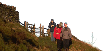
All the previous year's WWWs have been leading up to this! South of Arenig Fawr, SW of Bala is a wild and unvisited corner of Wales in which the summits of Dduallt and Rhobell Fawr lie. On a Recce this year, I evaluated the Wild quality as very high, and returned with a good start to the sun tan for the year. Paths - what are they then?
To get there: Head to Bala by your favoured route, then continue south on the A494 past Lake Bala. IMMEDIATELY after the 40mph restriction sign for Llanuwchllyn, turn right on road to Trawsfynydd. The start is at Dolhendre (GR 854309) 4/3mile further on. Park in the vicinity of the phone box by a bridge and meet here - more space 50m further along the road. This takes ~1.75 hours from S. Manchester. The walk starts prompt at 10am (it's going to be a long day).
The Route: Cross the bridge and straight ahead. Past a cottage, then right and right again at more buildings to emerge on Open Country at a stile. Path ends. Visit Castell Carndochan (good viewpoint), then S down ridge, turn R and cross very boggy ground and stream, aiming for high ground. Follow ridge line via Craig y Llestri, with doglegs to Cerrig yr Lwrch. (Valley option is less exposed, but wetter). Keeping to grass as long as possible, head for corner of decrepit forest, then the shortest line to the grassy north ridge of Dduallt. The marsh symbols are an exaggeration - it's a sea of deep heather. Follow knobbly ridge to Dduallt. The direct way on to Rhobell Fawr is blocked by ancient forest but follow me south on the ridge then via the forest edge. Pick up a narrow, overgrown firebreak - keep close for who knows what roams in the deep forest, Fangorn's darker cousin. A wider forest ride takes those who survive onto a Forest track. We head further south away from those you have known, turning right at a wall, heading for the summit of Rhobell Fawr - very rugged with several crags. From the summit head north, to skirt the W edge of the forest (now largely cut down). Eventually an old track will appear in a gully, taking us to the valley floor, where we head west on the farm track until tarmac. Cross bridge and turn R up the hillside before a farmhouse (Cwm-hesgen), to pick up an old path leading north-east up the valley. Path fades to nothing as we cross a stream, which we follow round to a ruin. With nothing but sections of sheep track to follow, we strike right into the wilderness. Keep to high ground, very easy to get mislaid, until Llyfnant is ahead (little sign of Man). Hard going to a stream, down to a fence and a lonely gate indicating the past existence of a right of way. Reach the road at some farm buildings (Buarthmeini). Turn right - we may take the road, but the proper route takes another path through a gate shortly after and after we gain another farm with some complex gate work, the final track down through the forest to the start point.
 |
| Dduallt seen from the NE at the end of April 2006. Empty country! |
Total Distance ~15miles. Ascent 1050m. Time 8-9hrs. Fit walkers only to apply and be prepared for rough, trackless going. There will be a plan B in the Bala area in the event of very poor weather. A Head Torch is essential. Compass advised, if you don't keep together. Once started I cannot vouch for significant short cuts (once S of Dduallt we're committed) - the alternative return 'track' (on the map but not on the ground) has no sign of a exit, so it would likely be a compass directed trudge across the vast Serengeti plain in the dark. Note the Clocks go back this Morning!
Dave Bone
")


